
 Facebook
 X
X
 Pinterest
 Copy Link
Check out Oahu’s Top Hiking trails from https://www.hawaii-guide.com/oahu/hiking-trails
Oahu Hiking Trails Guide
Best Places to Hike on Oahu
One of the best ways to explore Oahu’s natural wonders is on foot; you can stop and admire whatever catches your eye, take amazing photos at your leisure, and explore at your own pace.
Luckily, Oahu hiking trails offer something for everyone. If you’re looking for a laid-back stroll, check out Manoa Falls Trail with its incredible views of the lush Manoa Valley. You can even take a dip in the waterfall at Waimea Falls- sure to be the highlight of your hike. Looking for some of the most amazing views you’ve ever seen? Then hit the trail at Diamond Head- one of the best hikes on Oahu. All you need to experience Oahu’s best hiking trails are some good shoes and a sense of adventure. See you along the trail!
- The 10 Best Hiking Trails on Oahu – we’ve ranked the top 10 hikes & trails based on several important visitor criteria
- Zoom in on each trails’ location, with our Interactive Oahu Trail Map
- Explore all of Oahu’s hiking trails, categorized by region
Top 10 Oahu Hiking Trails
The numbered hikes listed here are our absolute favorites on the island of Oahu. There’s a lot to consider when ranking trails for visitors – trail length, difficulty, elevation change, views, clarity of the path (some trails are more “official” than others), and general safety. Whether you choose to take on these more challenging hikes or stick to adventuring on your own, we’re certain you’ll see Oahu from a completely new perspective after exploring these remarkable trails. Let’s countdown the very best trails on Oahu.
Maunawili Falls Trail
East ‘Windward’ Oahu Region
#10 Rated Hiking Trail on Oahu
Maunawili Falls is in the Maunawili Valley at the foot of the Pali Cliffs. It’s about 40 minutes from Waikiki. Follow Maunawili Road until you reach the residential neighborhood where a small sign marks the trail. The only parking is on the neighborhood streets.
It is a two-mile hike but takes a good two hours or so to reach the waterfall. When you reach the plateau, you can admire the view of the valley and jungle before the path heads downwards to the falls. The steps here are large and should be taken slowly.
You’ll reach the cascading falls where you’ll navigate across another stream and some boulders to reach the cool natural pool at the bottom of the 20ft waterfall.
Closure Notice: The Maunawili Falls Trail to close for two years
Beginning July 2021, according to the local news and the Department of Land and Natural Resources (DLNR), the Maunawili Falls Trail will be closed for two years for a long-term improvement project.
Pu’u Ma’eli’eli Trail
East ‘Windward’ Oahu Region
#9 Rated Hiking Trail on Oahu
This trail is also known as the Kaneohe Bay Pillbox trail and is considered easy enough for beginners. However, it might be better suited to those with a little more stamina as there are some steep inclines to contend with.
It takes between one to two hours to complete the 2.2-mile journey and is pleasant to travel as it is not overly crowded. It is about 40 minutes from Waikiki to the trailhead at 279 Kahekili Hwy. It is near enough Koolau Shopping Center across from the Valley of the Temples that you can park there and walk to the end of the guardrail along the highway to find the trailhead.
This is an excellent option as it is a shorter hike that gives you excellent views of the windward side of the island. While much of the trail is through a forested area, you will get peeks at the views and come across some lookout points overlooking K-Bay. Your goal is to reach the pillbox to get the full expanse of the bay below. The pillbox is one of many small bunkers/lookouts built by the military in World War II. The pillboxes have the best views on the island.
Aiea Loop Trail
Central Oahu Region
#8 Rated Hiking Trail on Oahu
This hike is the ideal hike for those who are not as active. Running just under five miles, you will be grateful for the shade and relatively flat pathways along most of the trail.
Along the loop, you can explore the beauty of native trees, in a cool, shady, verdant forest with lemon eucalyptus groves, Norfolk pine, native koa, and ʻōhiʻa trees.
The trail is located on the west side of Hālawa Valley, where you can also take in some impressive views from the ridge, including Pearl Harbor, Diamond Head, and the Ko‘olau Mountains. The beauty of the trail is that you will find something new at every turn. Halfway along the trail, a lookout point offers a stunning view of the Hālawa Valley.
Ehukai Pillbox Hike
North Shore Oahu Region
#7 Rated Hiking Trail on Oahu
For a breathtaking view of Oahu’s North Shore and the Seven Mile Miracle, you’ll want to take the Ehukai Pillbox Hike. This trail is just a mile and a half there and back and takes about an hour to 90 minutes.
However, this is not for the weak of heart, knees, or those with any other physical challenge. Severe inclines are endured for at least 20 minutes, although the first stretch is balanced by shade.
You can enjoy views of the North Shore from here. True to its name the trail features a number of “pillboxes.” You can stand on top of the pillbox to get the best view of coastline including Banzai Pipeline and Sunset Beach.
Manoa Falls Trail
Waikiki & Honolulu Region
#6 Rated Hiking Trail on Oahu
If you’re looking for a hiking trail that could be classified more of a “walking trail”, yet still offers up the gorgeous scenery, then Manoa Falls Trail should definitely be on your Oahu must-do hikes list.
If you’re like many people who either cannot hike the strenuous trails or you’re exploring with kids, you’ll be relieved to know that the Manoa Falls Trail definitely falls on the “walk” end of the walk-hike spectrum, with a roundtrip distance of just 1.6 miles and an uphill grade that isn’t too demanding.
The trail is located just a 15-minute drive from the hustle and bustle of urban Honolulu, but once you’re on its path, surrounded by the lush, verdant views of Manoa Valley, you’ll feel like you’re in a completely different world.
Ka’iwa Ridge Trail (Lanikai Pillbox Hike)
East ‘Windward’ Oahu Region
#5 Rated Hiking Trail on Oahu
The Kaiwa Ridge Trail, also known as Lanikai Pillbox Hike, is an intermediate hike that will take you to some of the most stunning views on Oahu’s windward side. Sitting above Lanikai Beach, Kaiwa Ridge Trail has a steady steep grade throughout the climb.
However, if you’re up to it, you will enjoy unbeatable views of the Mokulua Islands, Kailua Beach, and Lanikai Beach when you reach the top. It takes about an hour to 90 minutes roundtrip and you can choose how far up you wish to go.
The scenery along the trail offers breathtaking views whether you choose to complete trial another hour along the ridge or not. The trail ends at A’alapapa Street, about a mile from the trailhead.
Kuli’ou’ou Ridge Trail
Waikiki & Honolulu Region
#4 Rated Hiking Trail on Oahu
The Kuliouou Ridge Trail is about 4.4 miles round trip and takes a good three to four hours to complete. Less then half an hour from Waikiki, the trailhead is located at the end of residential Kalaau Place.
It is moderate in its challenge and features some stairs that make the climb easier. It is a pretty rocky terrain on steep inclines with many local varieties of plants and trees. The trail travels through several different environments showcasing the diversity of the Oahu landscape.
The trail continues through an interesting archway of banyan branches, to an even more breathtaking view from the ridge. Stairs make it easier to reach the final plateau where you will thank your lucky stars for persevering when you see the overwhelming views of beautiful East Oahu.
Makapuu Point & Lighthouse Trail
East ‘Windward’ Oahu Region
#3 Rated Hiking Trail on Oahu
If you are seeking a great view of Oahu’s southeastern shoreline – with tall sea cliffs and an azure blue ocean – Makapu’u Point is the location for a panoramic view of the coast.
Situated on Kalanianaole Highway on the southeastern tip of the island, Makapu’u is on the right side of the highway about 12 miles east of Honolulu, past Koko Head, Hanauma Bay, and Sandy Beach Park. Makapu’u is a remnant of a volcanic ridge that rises over 600 feet from the ocean. It is the easternmost point on the island of Oahu.
From the lookout, panoramic views of Manana Island and Black Rock Island can be seen as well as the expansive blue ocean. On clear days you can see the entire eastern shore of the island and sometimes you may be able to spot the islands of Molokai and Lanai. This is an ideal place to whale watch in the season. Look for old WW11 bunkers on the cliff edges – some of the many relics from the war that still exist on Oahu.
Koko Crater Railway Trail
Waikiki & Honolulu Region
#2 Rated Hiking Trail on Oahu
The Koko Head Hike railway “stairs” is a short drive from Diamond Head and Waikiki. It puts you through your paces and can be a challenge even for the fittest of the fit. However, if you’re up to the challenge it is worth the effort to reach the Koko Head Crater summit.
Although it is a short hike of 1.4 miles, it is grueling with an extreme incline that will have you doubting you can ever reach the top. A relic of World War II, the military constructed Koko Head Railway to transport supplies and soldiers. The site has had many functions until it was finally passed onto the City of Honolulu and became Koko Head Regional Park in 1966.
The trail heads up 990ft at a very steep incline, and the views at the Koko Head Crater summit are 1208ft above sea level. There are 1,048 railroad ties to climb and then 30 feet to the lookout.
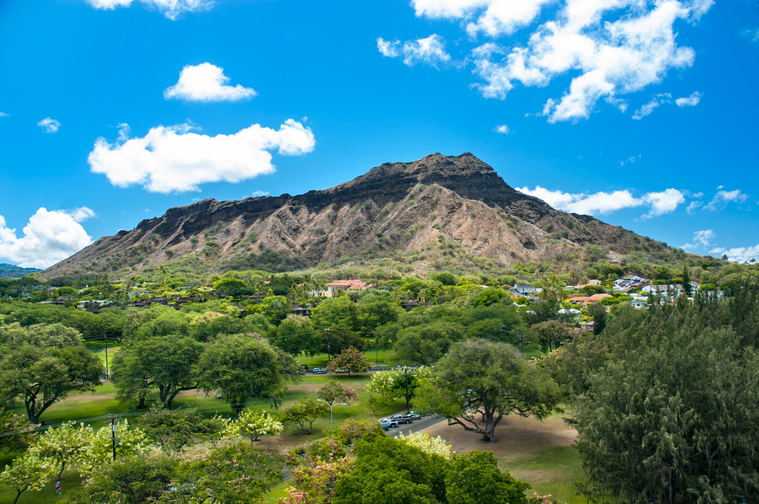
Diamond Head (Leahi) Trail
Waikiki & Honolulu Region
#1 Rated Hiking Trail on Oahu
The trail to the summit of Diamond Head (Hawaiian name Le’ahi), near Waikiki, was built in 1908 as part of the U.S. Army Coastal Artillery defense system.
From the trailhead to the summit of Diamond Head Crater, it is 0.8miles (1.3km) one way, and it is a 560 foot (171m) climb from the crater floor. Allow 1.5-2 hours for a safe and leisurely round-trip hike. The trail follows an uneven and at times steep terrain, and caution as well as appropriate footwear are required.
At the top, there are extensive 360-degree views of Waikiki, Honolulu, and the surrounding area. From here you can clearly view the bunkers situated along the crater rim that was built in 1915. There are also sweeping views of the southeastern Oahu coastline towards Koko Head and the offshore islands of Moloka’i, Lana’i, and Maui. The elevation at the summit is 761 feet (232m).
Effective May 12, 2022, reservations are required to visit, and all visitors parking vehicles in the crater will be required to book in two-hour time slots beginning at 6 a.m. (two consecutive slots can be booked). Walk-in and drop-off visitors will be subject to one-hour entry time slots. Arrival and exit times will be enforced to assure adequate turnover to allow for later arrivals. Park hours and visitor entrance fees are available at Hawaii DLNR.
